Third day on ferry, am getting antsy to get off and ride.
Today we stopped at Wrangal, Petersburg, Sitka, Juneau and Haines. These are the last of the photos I'll publish from the ferry ride.
Mendenhall Glacier , Juneau
Next three photos are of the procedure to secure the ships mooring (?) ropes to the dock.
First the deck hand throws a leader to the shore man to catch and then pull the heavier rope over.
Pulling the heavy rope over to hook on the ______?
Next the machinery onboard pulls the ropes taught to secure the vessel to the dock.
These ferries to not dock where the fancy cruise ships do. These terminals are at a remote distance from town, like the case in Juneau.
As dusk falls we spot several cruise ships leaving Skagway for Juneau.
Another cruise ship from Skagway, with a glacier valley on the left.
We arrived in Haines 11:30 pm. Finally off the ferry, rode the several miles into Haines to find the motel for the night. Tomorrow we ride to the Canadian border.
Water beds are fine, but being a land lubber has it's privileges. Like full length hotel beds. 😎
Hold my keyboard and watch this! 🙃
Awesome pictures so far.
Thanks Jan.
3 days on the ferry gives an insight into the distance involved.
Or the speed of the boat.
Only done two drive on ferry trips and that a long time ago.
Melbourne to Launceston and Port Lincoln to Kangaroo Island then on to Adelaide.
Both much shorter journeys but still interesting.
Was wondering about how a CanAm would do on the Alaska Highway, rode over 12 miles of gravel today. Seeing all that gravel piling up in the middle of the road made me wonder...
Downtown Haines at 9 AM.
Finally off the ferry and back to riding. Left Haines around 10 AM, arrived in Bear Creek, Yukon at 6:30, 330 miles today. Felt so good to be riding once more. That is until I hit those last 100 miles of the worst of the worst of the Alcan. Frost heaves, gravel patches, road work, dips and splits in pavement.
Was a slight drizzle in Haines, other than that, no rain all day. Temp even got up to 74 in the afternoon.
Tomorrow I enter Alaska and head up to Fairbanks.
Brstr, the max speed of that ferry is 17.1 knots. It's advanage is it can navigate through narrow channels where large vessels cannot go. It has both a side and rear vehicle loading doors. There are many small villages scattered on the islands. This ferry, as well as carrying tourists and their camping rigs, it also drops off supplies in the larger ports that are then distributed to the villages on smaller ferries.
You might have heard that Juneau, the capital of the state of Alaska, in our only state capital that is not accessible by land. It's float in or fly in.
Interesting country there.
Had to look it up and revised my knowledge a bit more.
Never realised that Alaska has the strip of land along the coast.
And satellite pictures sure show some rugged terrain.
Thanks for giving a clue.
What Khud said. Top of the World was closed sporadically while we were there, same with the Klondike south of Dawson, all due to fires. Don't think there are any issues now. I think there was a washout on the Dalton about the same time. But that is all old news now. As you know the condition of the highways change quickly in the North and the News of it travels slowly. You get what you get.. I think a Sidecar is about the best beast to tackle those roads. Fun and scary all at the same time.. Enjoy the frost heaves, especially through the Yukon.
The ride from Haines to Haines Junctions is an easy 146 miles, up over Chitkat Pass at 3510 ft elevation with gentle slopes, cross wide meadows then easy descents to Haines Junction. Relaxed border crossing into B.C. Canada. Then into Yukon Territory.
Refueled in Haines Junction, then decided to go for Beaver Creek, Yukon on the Alaska border. That was a mistake.
The last 100 miles of the Alcan in Canada is poorly maintained, long stretches of gravel and dust. Oncoming trucks, RV's and trailer railers do not slow down, having no consideration of the cloud of dust they are coating the other vehicles with, or. motorcyclist breathing. Worse, their dust cloud reduces visibility to feet, totally blinding the other drivers. If you stop and wait for the wind to blow the dust away, you run the risk of being hit by the vehicle behind you as it s not slowing down.
Add in the frost heaves, splits, holes and pavement breaks makes for a very trying driving situation.The Hotels.com said Dot's Cafe and motel in Beaver Creek had no rooms. Yet when I arrived they had plenty. I assume the new owners do not wish to pay the fee to Hotels.com. Eight to ten motorcyclist stayed there that night.
Early the next morning, on to Fairbanks. But first the border crossing.
On the US side there was plenty of road construction, but the best looking flaggers. Friendly too.
After several misleads with the GPS, finally found the Honda motorcycle dealer after the third try. Made an appointment to get an oil change and general bike inspection on Tuesday, the 22, after I return from Prudhow Bay and the Haul Road (Dalton Highway) roads.
With that set up, left early, 5:30 the next morning for Coldfoot. The mid-point of the ride to Deadhorse. I would have taken more photos but this was the worst road I have ridden on this trip. Was more concerned about being thrown off the rig on a frost heave, or breaking a wheel in one of those bottom-less pot holes. Potholes and pavement cracks where you cannot see the bottom. Scary...
Talking with one of the Haul Road truckers, they even said that section from the start of the Dalton to Coldfoot is the worst. Now In Coldfoot for the night, tomorrow on to Prudhoe Bay.
Sorry no photos today. The internet connection here in Deadhorse is very slow or everyone got off work and is now online. Will add photos when I get a stronger signal.
WIFI issue corrected finally two days later. Welcome to the North.
Good to know things are proceeding.
I:E no dis... no I won't use that word.....
Continue on my good man.....
When we lived in Fairbanks, my then teenage daughter had a girl friend whose father worked for the Alaska DOT, and was responsible for the maintenance of the Dalton Highway. He told me that it was their policy to let the first 20-30 miles of the Dalton at the southern end remain in poor condition. The intent was to dissuade tourists from driving up the road. I asked him why the rest of the road was in crappy condition..... he did not answer.
Update: Because I know that Jan is busy driving his Red Dog sidecar rig, has spotty or iffy WiFi in very few places, and some of you are hankering for news....
He did arrive in Prudhoe Bay/Deadhorse, spent a day there, then left there on Saturday morning, in 32* F temps, and rode South to Coldfoot, and before he reached Coldfoot the temps were up to 74* F, so he had to remove all of his clothes, and ride buck nekked the last few miles (joke)
![]()
That was the last I heard from him. Possibly a Grizzly saw him riding buck nekked, and hitched a ride southbound with Jan, as he does have a open seat area in his sidecar, so.....
![]()
I want to presume that he left Coldfoot on Sunday, and arrived at Fairbanks Sunday evening, so that he can rest up today, Monday, wash his rig down, as he posted a picture of it to me with it all covered in Calcium Chloride, and he needs to have it relatively clean for his Oil Change appointment tomorrow at the Honda dealer in Fairbanks.
He did tell me that he came across a newly covered section of roadway that the DOT had just watered down and covered with a fresh batch of Calcium Chloride, and those of us here that have ridden/driven the Haul Road, or the Dempster Hwy, or the Campbell Hwy, etc...are all too familiar with what Calcium Chloride can do to your vehicle.
WE should hear from Jan today, whilst he is in Fairbanks, as he will have better WiFi.
Two Million Mile Rider
Exploring the World in Comfort
Thanks FM for keeping everyone up to date while the wifi was impossible.
Now we continue...
July 17th, Leaving Fairbanks early AM with Coldfoot in mind. Here are scenes from the road.
North of Fairbanks, Livengood is the turn off for the Dalton Highway.
Over the years adventure riders have covered the road signs with their little stickers to the point the sign is unreadable. It used to be riders would carry a pen or marker to leave their name and date on the signs. Now, everybody has to have a preprinted sticker to leave their mark. Modern version of post-it notes
The majority of the Dalton is hard pack dirt gravel with rough patches and frost heaves every so often.
Since the Dalton, also known as the Haul Road, was built to service the north slope oil fields and the Alaska pipeline, we will parallel the pipeline all the way to Prudhoe Bay. Many times we will cross it, sometimes it will be buried, other time exposed. There are several pumping stations along the pipeline to either keep the crude oil flowing or to slow it down when desending a steep slope.
The Yukon River bridge has a wood surface that is slippery when wet. Luckily today it is dry. Notice the steep slope of the bridge?
On the other side is a pull off where you can get a good photo of the pipeline, your rig with the bridge in the background.
.Bought gas in Coldfoot. Think your gas is overpriced where you live? How about paying $7.499 a gallon.
Serene scene from the north.
I was concerned about clogging the Wings radiators with mud and muck from the road. So I fabricated cheap bug screens using a hot glue gun, attached them with Velcro, to catch any mud or muck before it reaches the radiator grills. The Wing has two radiators that are recessed and not easy to reach and clean. These I will discard them after we leave Canada.
On another ride up here, the bike's radiator grill was clogged so bad the engine started to overheat. Has to stop, find a twig and clean it enough to continue.
What a peaceful scene, until the Alaska State Bird finds you... on other words, their giant mosquitos make stoping anywhere more than a few minutes miserable. Unless the wind is blowing, then no state bird bothers you.
Information on this lake near Coldfoot
We reach Coldfoot camp, truck stop, fueling station, restaurant and rooms for rent.
Tomorrow we ride further north to Prudhoe Bay.
Attached Files:
Today we make the final push to reach Prudhoe Bay before the rains move in. Leaving Coldfoot we head straight north to cross the Brooks Mountain range, then out onto the tundra to Prudhoe Bay.
A now familiar friend accompanies us., With a different foothill in the rearview mirror.
A slow climb up the valley to Atigun Pass ahead.
Meet our first vehicle of the day. Wonder where they spent the night as we are a good six hours south of Prudhoe Bay?
Climbing up Atigun Pass, stopped to look back, at from where we came. The water from this side will flow to the Yukon river and out to the Bering Sea which is part of the Pacific Ocean.
From the top of the pass, looking at the northern downward side. Rain from this side of the Brooks Range will flow northward to the Arctic Ocean.
Then look to the left to see where the road courses the narrow valley going north.
Once away from the Brooks Range, we are out on the featureless tundra for the next 150 miles.
Arriving in Prudhoe Bay, looked for the two signs that prove I was here.
First found the North Slope Borough administration building sign. Who are they? Though it appears the oil companies run the show here, there are representatives from the area native population who have a say in drilling, building and operations in Deadhorse, though they don't actually live in the village.
For those not aware, all of the people actually in Prudhow Bay/Deadhorse are workers who live somewhere else. There are no permanent residents. It's an industrial oil field work camp.
The 'infamous' Deadhorse sign is so rusted, faded and covered with motorcycle rider stickers, it no longer holds the appeal it once had.
The photo should be titled, "My rig, Red Dog and litter that won't blow away".
Now to find my hotel. One cannot just ride into Deadhorse and expect to find a room. You have to make reservation at least 24 hours in advance for security reasons. There are also certain rules that will get you thrown out asap.
Like: No alcohol, no firearms, no drugs, no fighting, no violence, etc. These apply to workers and visitors.
Hmmm, doesn't look like a hotel, more like a manufacturing plant...
But the sign out front says it all. And the parking lot across the street.
Also the sign tells me the time...
And the temperature.. the only sign like this here in Deadhorse.
Am covered for the night, ready for a good rest. By the way, rooms are expensive here, BUT it does include all three meals, free laundry rooms exercise facilities, libraries, TV lounges, and room service. Many workers here are two - weeks here, then back home for some days.
Finally in Prudhoe Bay, it's time to organize the paperwork to document my Iron Butt ride south to Key West, Florida, which is only 90 miles from Cuba.
In case you were not aware, I am attempting to complete the Ultimate Coast to Coast Iron Butt challenge, riding from Prudhoe Bay to Key West in less than 30 days, for the third time. I have made three previous attempts, with two complitions. First rode it on two wheels, a BMW 1150 GSA in 2010; then on three wheels, a Russian URAL sidecar in 2013, and now to celebrate my turning 80 in May of this year, on my Honda Goldwing with a Hannigan sidecar.
If completed, I will be the oldest person to meet the challenge and submit the necessary paperwork for IBA certification.
Tonight we rest.
p.s., whenever I say "we", I am referring the the rig and myself. I am riding this challenge solo as were all of my IBA rides.
Awesome trail yarn here.
Mining camps the same everywhere it seems.
Except there due to local no doubt they have to allow the public to share facilities.
Usual the living is good at camp quarters.
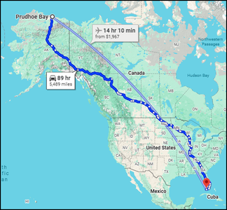
I will do my part to follow Jan's progress in his Ultimate Coast-to-Coast challenge and try to keep up by mapping his daily progress.
First, let's have some perspective for those maybe not familiar with the geography, or not from the US, here is what Jan is attempting to do within 30 days.
(click to enlarge)
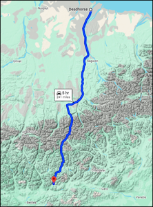
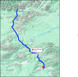
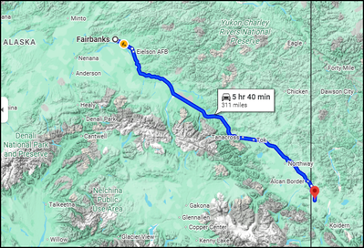
Now to his daily progress.
UCC Day 1 - 7/19/25 - Prudhoe Bay to Coldfoot, AK
UCC Day 2 - 7/20/25 - Coldfoot to Fairbanks
UCC Day 3 - 7/21/25 - Fairbanks, AK - Maintenance and rest day
UCC Day 4 - 7/22/25 - Fairbanks to Beaver Creek, YT
Jerry
I fly (and ride) to free my mind from the tyranny of petty things. Antoine de Saint-Exupéry
- 29 Forums
- 11.7 K Topics
- 91.7 K Posts
- 3 Online
- 5,615 Members


